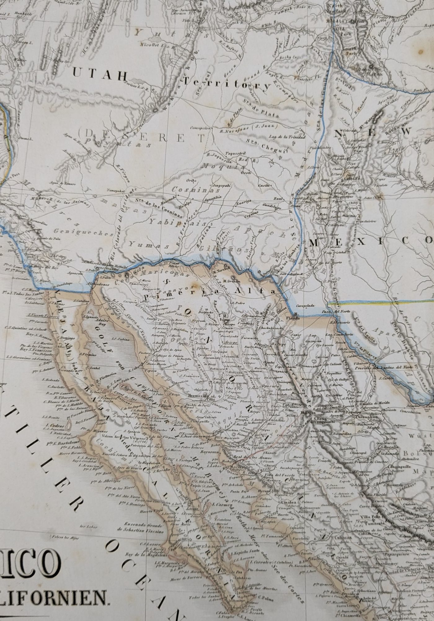
Mexico, Texas und Californien (Shows the Mormon State of Deseret)
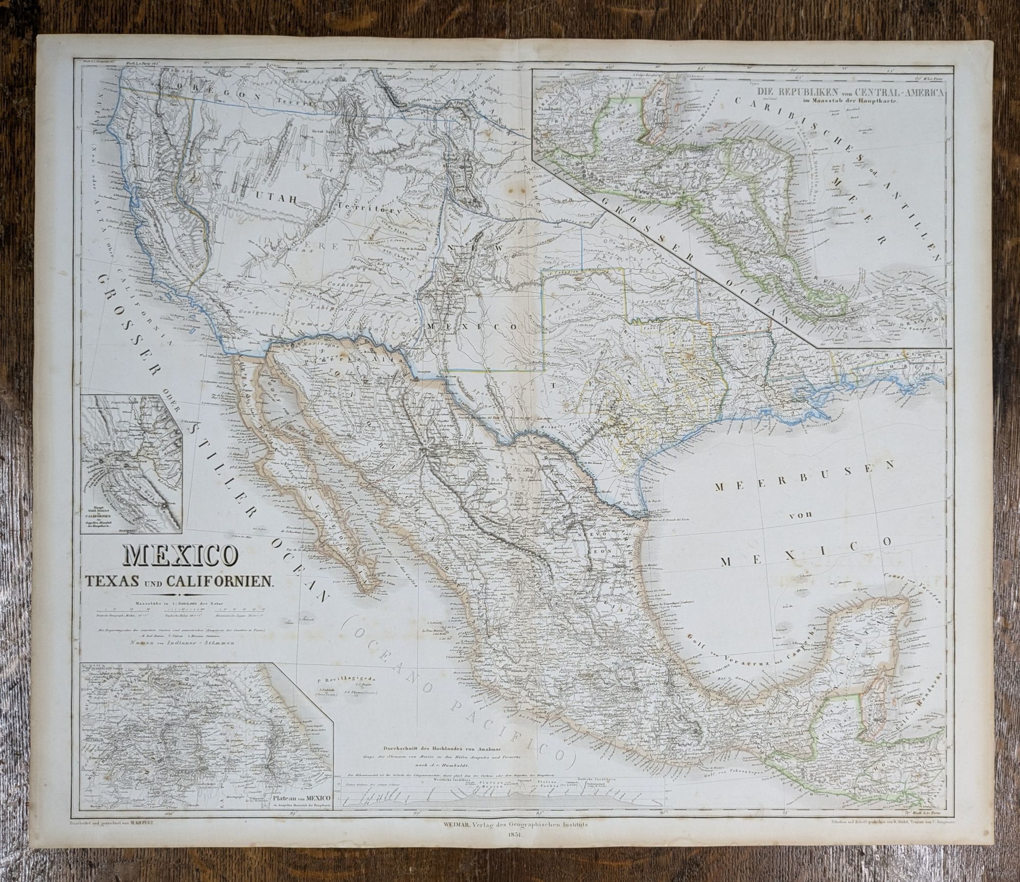
- Weimar: Verlag des Geographischen Instituts, 1852
Weimar: Verlag des Geographischen Instituts, 1852. 25.5" x 22.5". Color outline. Illustrating the proposed State of Deseret, including its port towns of Los Angeles and San Diego. Fine large format map, which includes an exceptionally detailed outline of the proposed state of Deseret (Utah Territory), possibly the single best illustration of this proposed state.
Kiepert's map of the Southwestern United States, originally issued in 1847, provides a fascinating view of the changing features of the region. Over a period of nearly 20 years, the map was frequently updated to reflect the results of the explorations and surveys in the area, in addition to the fluctuating geo-political borders from the Mexican-American War, Treaty of Guadalupe Hidalgo, Gadsden Purchase and the mutating territorial boundaries of the West, up to and immediately following the American Civil War.
An excellent study of the evolution of the west. In addition to showing Deseret, the map includes a pre-Gadsden Purchase boundary with Mexico and locates the German, French, and Mainzer Colonies in Texas, as well as a number of early counties. The results of Fremont's explorations and surveys are noticeable. Quite a few Indian tribes still appear, along with early routes through the west.
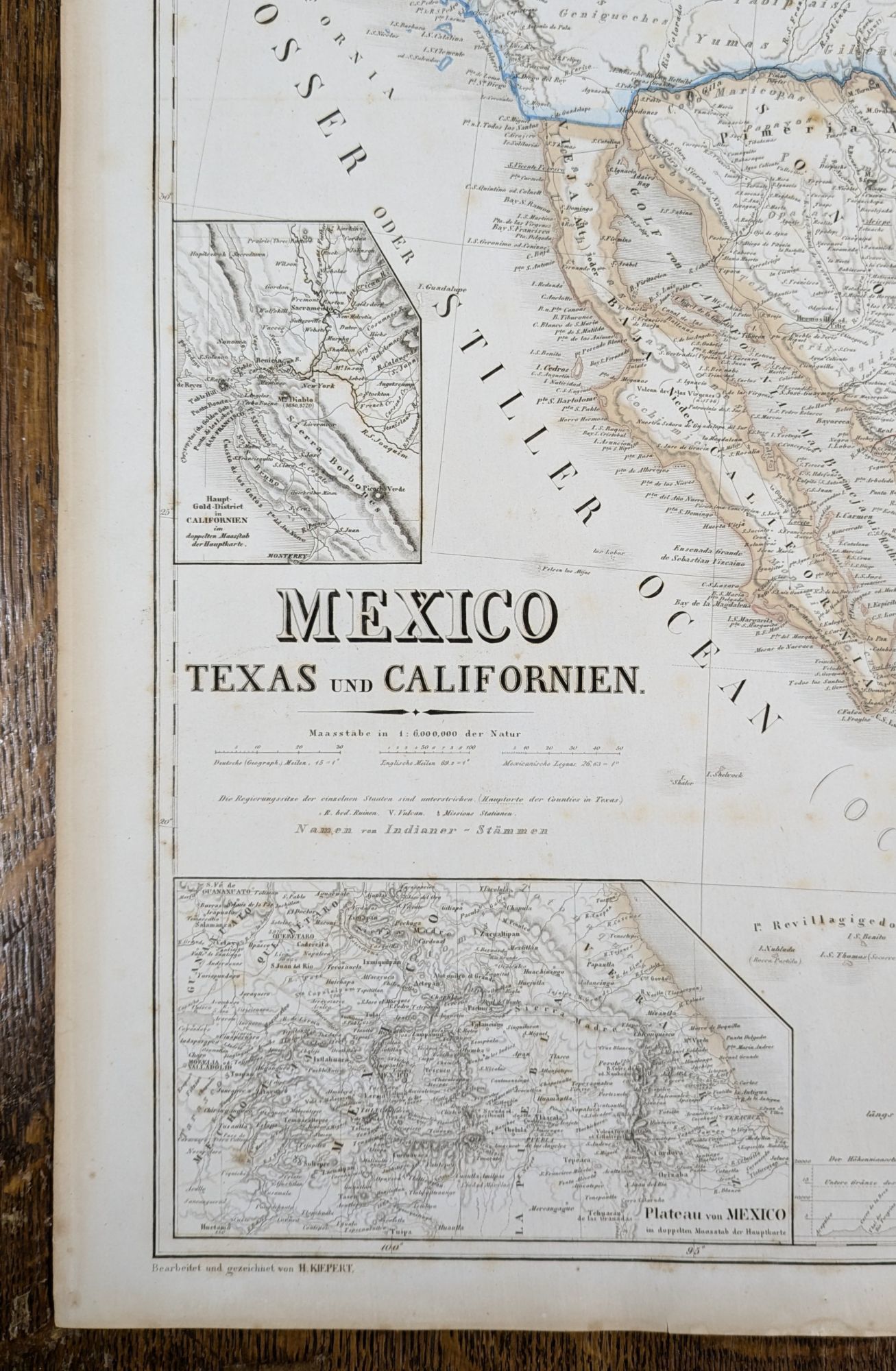
With insets of "Haupt Gold-District in Californien," "Plateau von Mexico," and "Die Republiken von Central-Amerika." Additionally, there is a profile from Mexico to Acapulco and Vera Cruz after Humboldt.
This map would have been produced for the German market, and it would have supplied many immigrants with his or her first view of their new country. This example also includes two pages of German text, including a footnote revealing the primary sources of the map. Map of Oregon and Upper California (Fremont), Military Reconnaissance of the Arkansas, Rio Del Norte and Rio Gila (Emory), Memoir of a Tour to Northern Mexico (Doniphan), and Expedition in 1846 and 1847 (Wislezenis), and others.
The map appeared in Kiepert's "Allgemeiner Hand-Atlas der Erde und des Himmels nach den besten astronomischen Bestimmungen, neuesten Entdeckungen und kritischen Untersuchungen entworfen." Rumsey notes "This is a marvelous atlas, full of interesting details.
Kiepert's map of the Southwestern United States, originally issued in 1847, provides a fascinating view of the changing features of the region. Over a period of nearly 20 years, the map was frequently updated to reflect the results of the explorations and surveys in the area, in addition to the fluctuating geo-political borders from the Mexican-American War, Treaty of Guadalupe Hidalgo, Gadsden Purchase and the mutating territorial boundaries of the West, up to and immediately following the American Civil War.
An excellent study of the evolution of the west. In addition to showing Deseret, the map includes a pre-Gadsden Purchase boundary with Mexico and locates the German, French, and Mainzer Colonies in Texas, as well as a number of early counties. The results of Fremont's explorations and surveys are noticeable. Quite a few Indian tribes still appear, along with early routes through the west.
With insets of "Haupt Gold-District in Californien," "Plateau von Mexico," and "Die Republiken von Central-Amerika." Additionally, there is a profile from Mexico to Acapulco and Vera Cruz after Humboldt.
This map would have been produced for the German market, and it would have supplied many immigrants with his or her first view of their new country. This example also includes two pages of German text, including a footnote revealing the primary sources of the map. Map of Oregon and Upper California (Fremont), Military Reconnaissance of the Arkansas, Rio Del Norte and Rio Gila (Emory), Memoir of a Tour to Northern Mexico (Doniphan), and Expedition in 1846 and 1847 (Wislezenis), and others.
The map appeared in Kiepert's "Allgemeiner Hand-Atlas der Erde und des Himmels nach den besten astronomischen Bestimmungen, neuesten Entdeckungen und kritischen Untersuchungen entworfen." Rumsey notes "This is a marvelous atlas, full of interesting details.