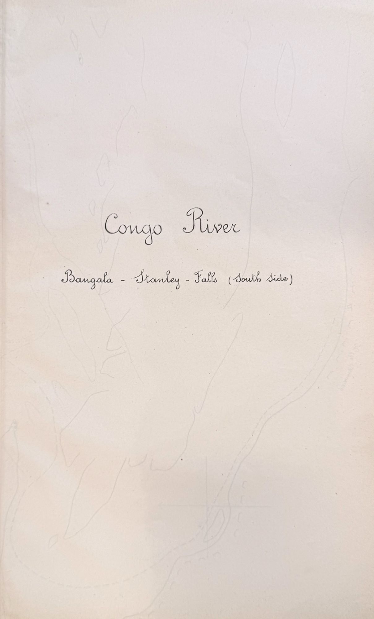
Congo River, from Leopoldville to Stanley Falls [Manuscript title]
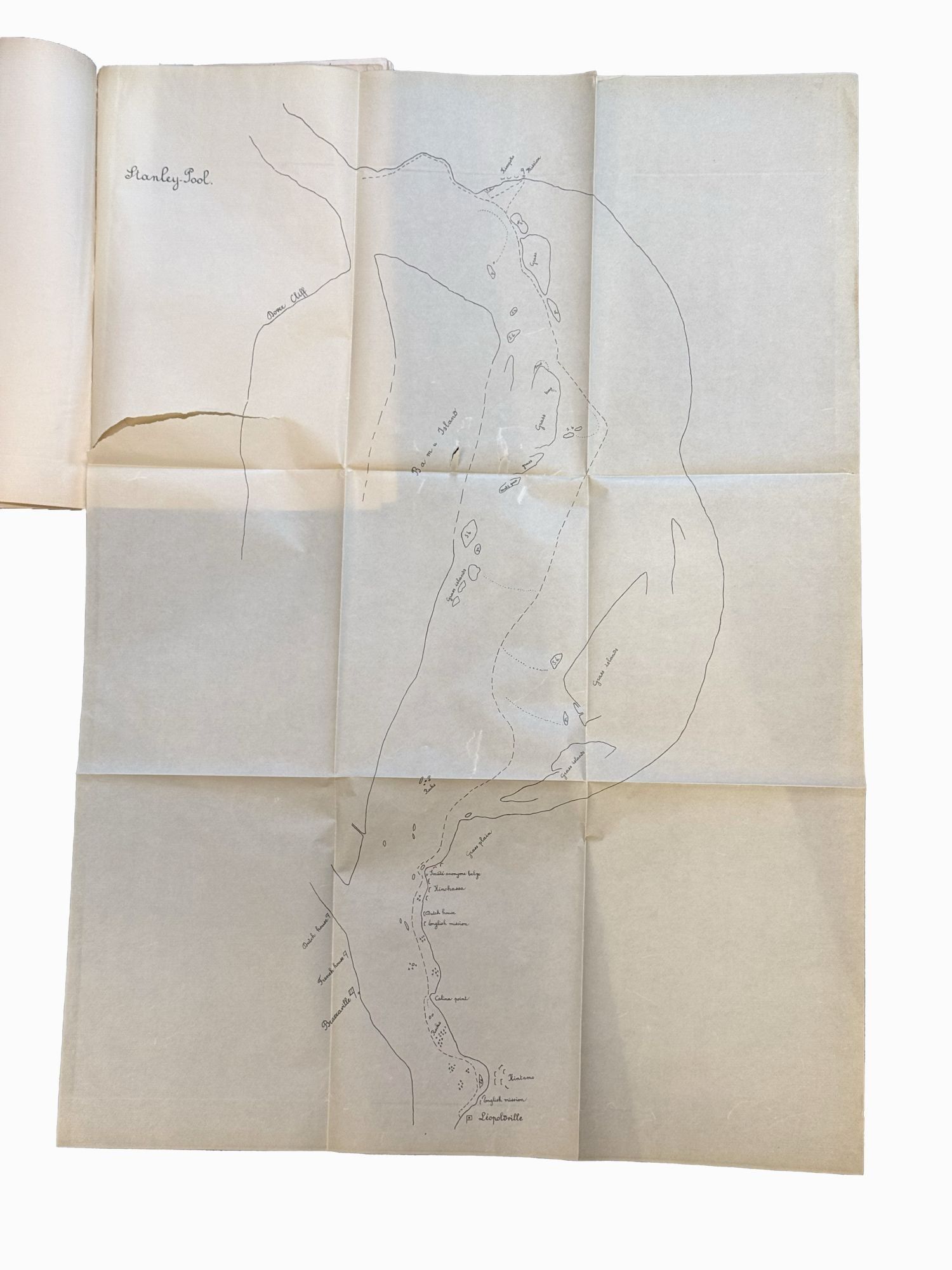
- Manuscript title leaf (verso blank), 1 large folding map, Leopoldville to Stanley Pool], and 151 navigation maps, all printed li
- [Belgium , 1890
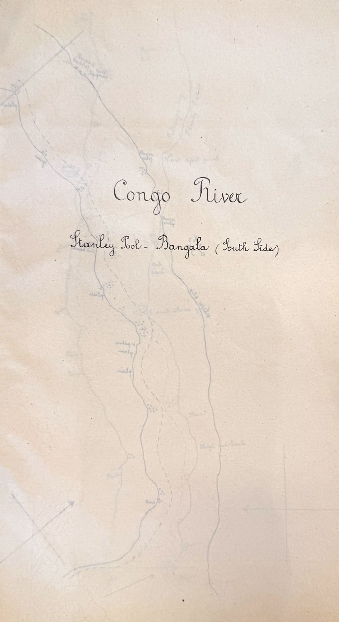
[Belgium, 1890. Manuscript title leaf (verso blank), 1 large folding map, Leopoldville to Stanley Pool], and 151 navigation maps, all printed lithographically, paginated as follows: [1, title:] Congo River, Stanley Pool - Bangala (South Side), 1-71; [1, title:] Congo River Bangala - Stanley - Falls (South Side)], 1 (double-page), 2-79. Paper with Belgian watermarks, rampant lion, surmounted by a crown and orb, large banner: L’Union Fait La Force, with a cross pendant beneath; or Royaume | De Belgigue surrounding a smaller crest. 1 vols. Small folio. Black flexible cloth, manuscript label to upper cover. Short tear at blank margin of folding map. Black morocco backed slipcase and cloth chemise. Manuscript title leaf (verso blank), 1 large folding map, Leopoldville to Stanley Pool], and 151 navigation maps, all printed lithographically, paginated as follows: [1, title:] Congo River, Stanley Pool - Bangala (South Side), 1-71; [1, title:] Congo River Bangala - Stanley - Falls (South Side)], 1 (double-page), 2-79. Paper with Belgian watermarks, rampant lion, surmounted by a crown and orb, large banner: L’Union Fait La Force, with a cross pendant beneath; or Royaume | De Belgigue surrounding a smaller crest. 1 vols. Small folio. Remarkable and unrecorded navigation guide for the Congo River from Leopoldville and Stanley Pool up river to Bangala Station and Stanley Falls (corresponding to modern Kinshasa and Pool Malebo to Makanza and Kisangani), printed on Belgian watermarked paper and titled in English with a manuscript subtitle suggesting a deeply practical purpose:
The Upper Congo has not been completely surveyed as regards the depth of the navigable channel. It would not be advisable in the present state of our knowledge, to place on the river steamers drawing more than 4 feet with full cargo.
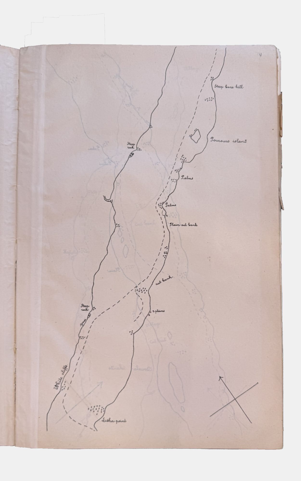
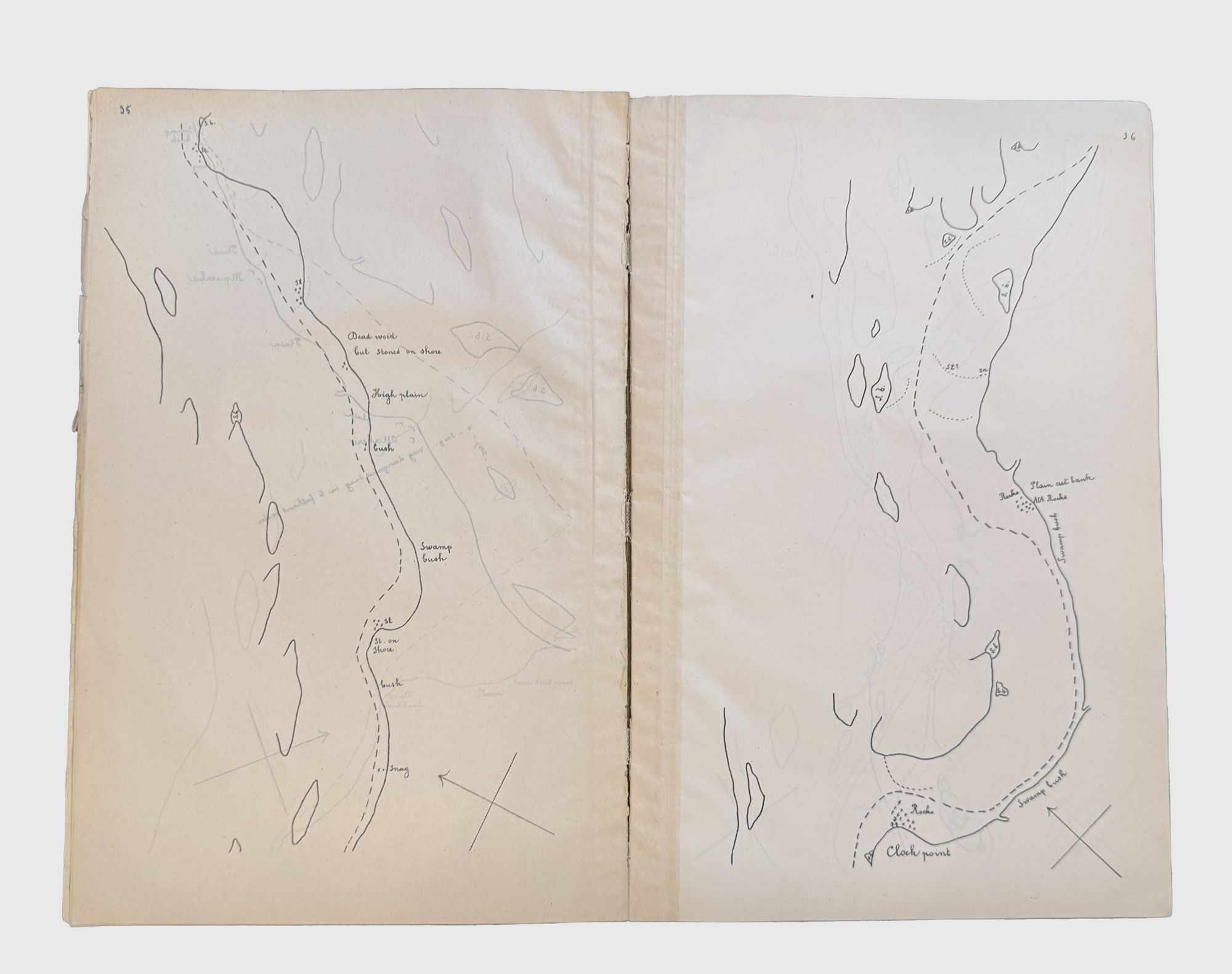
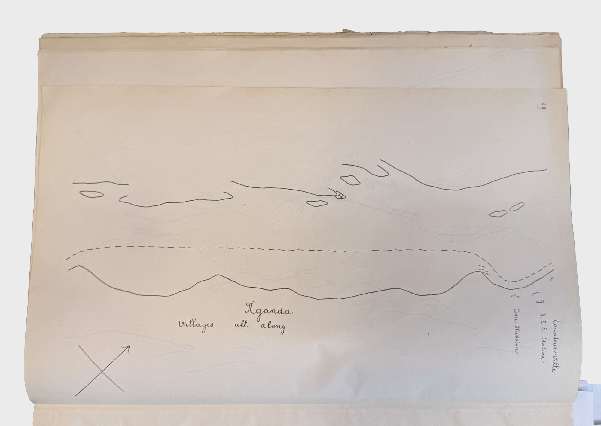
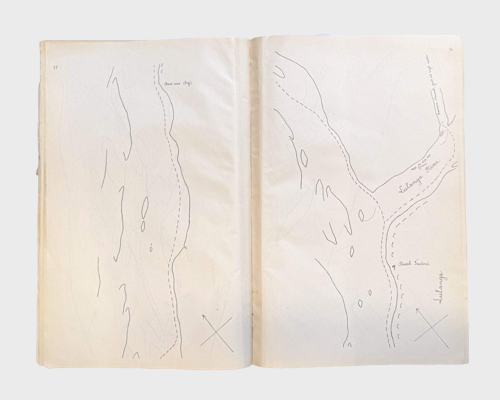
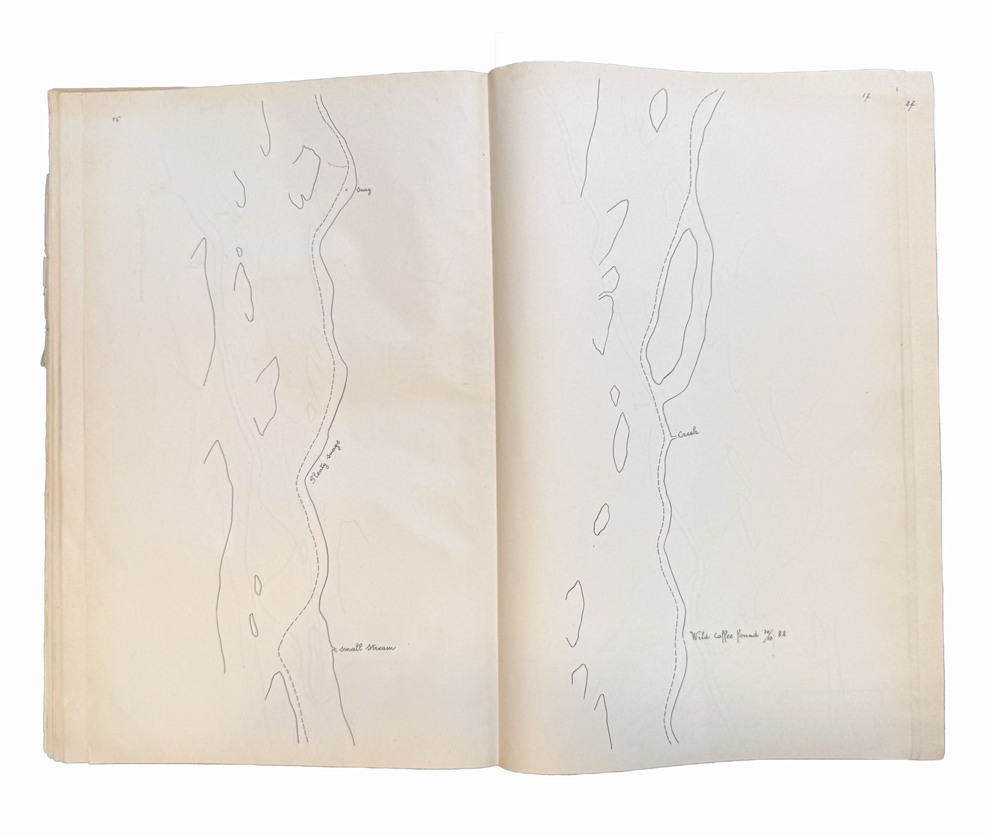
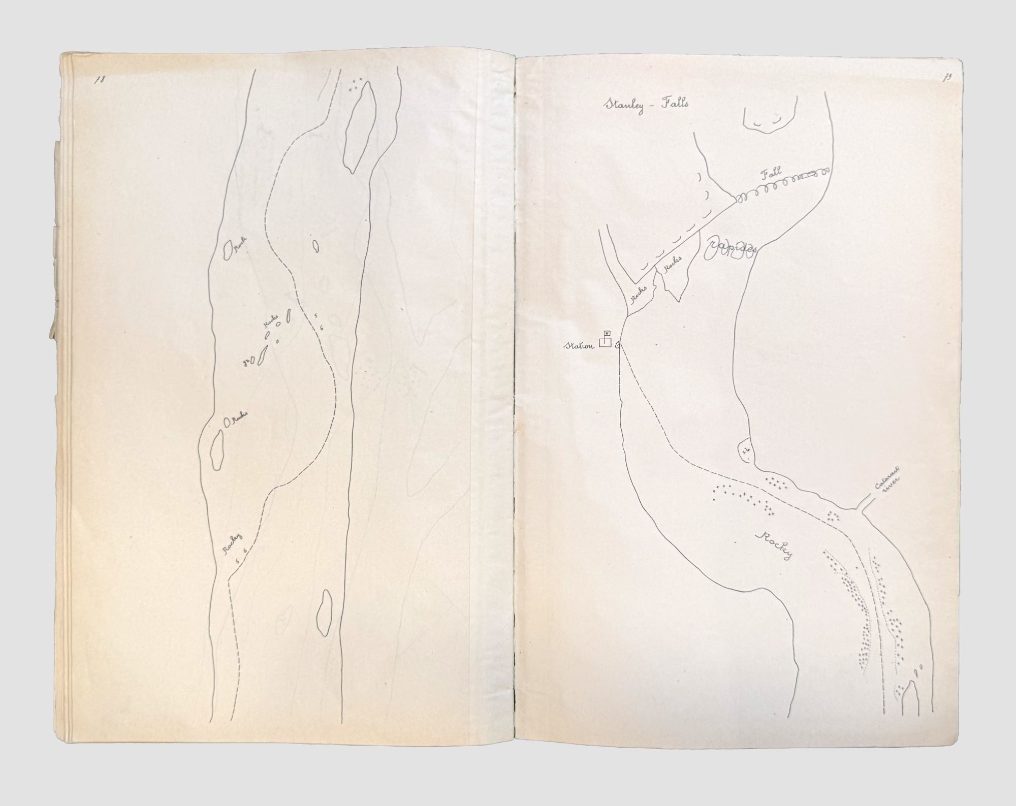
The strip maps show compass orientation and chart a navigable line with occasional soundings, reporting navigation hazards, riverbank geography and vegetation: “sand”, “swamp bush” or “s.b.”, “plains”, “rocks”, “stones”, and “dead trees” (essential to the wood-burning engines of the steamers), landmarks (“Clock Point” and “One Palm Point”), as well as settlement names and foreign missions or outposts. The chart is in two parts, with pages numbered consecutively; there is no scale but occasional distances in yards are denoted in identifying snags or hazards. The spelling is a curious mixture of English and French orthography for indigenous names; the calligraphy is distinctly continental.
In the first sequence, Up-river to Bangala Station, foreign stations named include the Eng[lish] Mission at Lukulela (established by Grenfell in 1884); the French Station; “Equateur Ville” (founded by H.M. Stanley, 1883, later renamed Coquilhatville, now Mbandaka), S.E.E. Station, and the Am[erican] Mission, between Ilganda and Wangata; the “Dutch Factori” at Lulanga;and Bangala Station. In the second sequence, continuing to Stanley Falls, there is one specific reference, “Wild Coffee found 30/10 88”. Other locations named along the way include Basomela, with a nearby note “high clearing prob. abandoned village”; “Isangi (Rashid Mohamed)”, a reference to the slave-trading nephew of Tippu Tib (also dating to ca. 1888); and arriving at Stanley-Falls Station.
Joseph Conrad was in the Congo from May to December 1890; two notebooks survive from the trip (held at Houghton). The first part of his trip was spent in overland journey from Matadi to Stanley Pool (now Kinshasa), and is recorded in The Congo Diary. Upon arrival there, with just sufficient time to begin a hostile relationship with Camille Delcommune, deputy station manager for the Société Anonyme Belge pour le Commerce du Haut-Congo (SAB), Conrad was immediately assigned as supernumerary on the fifteen-ton steamer Roi des Belges. This was one of several shallow draft paddle-wheel steamers in service on the upper Congo River since the inauguration of river traffic in late 1884. The Roi des Belges had a Danish captain, Ludvig Koch, and there were other Scandinavian captains on the river.
The Up-River Book, Conrad’s other notebook, is a detailed navigation record of the journey from Stanley Pool to Bangala, about half of the 985-mile journey to Stanley Falls (Kisangani). The notebook is dated 3 August 1890 and ends on 19 August. The upriver trip of the Roi des Belges was swift: shipping records indicate its arrival at Stanley Falls on 1 September, a record journey (Sherry, pp. 51, 377-8). “The precision, accuracy and factual observation are focused on the Congo's bends, bights, bores, islands and currents and on landmarks and settlements along the river, a necessary record if he were to fulfil his contract to command ships” (Last Essays, eds. Stevens & Stape, p. xxxvii). Conrad was 32 years old, and these diaries record his regular use of English in his daily work and private diaries. On the downriver trip from Stanley Falls, Conrad himself piloted the steamer after Koch became ill. “Many points of identification and navigational records in this notebook refer to charts in the possession of Captain Koch, probably provided by the SAB. These charts, in turn, probably corresponded to the recently completed ten-panel map
by George Grenfell, who worked closely with the Company” (Stevens & Stape, p. 462).
The place names and geographic markers correspond closely to those on Conrad’s route in the Up-River Book, with some spelling variations; the chart numbers in Conrad’s notebook do not refer to this map’s numbers. This map is not the chart owned by Captain Koch; it is a contemporary company production for similar practical use by the polyglot officers who piloted the river steamers. Although Equateur (Equator station) was officially renamed Coquilhatville in 1886, it took some time before this gained common usage, and the name is unchanged here. There is the marking of a coffee tree sighted with date 30/10 88, suggestive of a production date circa 1889-90.
This was a busy river (there were eleven steamers on the river when the Roi des Belges made its record trip. In the end, “[f]requently ill, usually rushed, harried by both his European colleagues and Congo natives” (Stevens & Stape, p. xxxvii), Conrad left the Congo. He followed the sea until 1894, and then embarked upon his literary career. He famously transmuted his experiences in the Congo into “Heart of Darkness”. Norman Sherry, Conrad’s Western World (Cambridge, 1971); Conrad, Joseph. Congo Diary and Other Uncollected Pieces. Edited and with Comments by Zdzistaw Najder (Doubleday, 1978); Conrad, Joseph. Last essays. Edited by Harold Ray Stevens and J. H. Stape (Cambridge, 2010)
The Upper Congo has not been completely surveyed as regards the depth of the navigable channel. It would not be advisable in the present state of our knowledge, to place on the river steamers drawing more than 4 feet with full cargo.
The strip maps show compass orientation and chart a navigable line with occasional soundings, reporting navigation hazards, riverbank geography and vegetation: “sand”, “swamp bush” or “s.b.”, “plains”, “rocks”, “stones”, and “dead trees” (essential to the wood-burning engines of the steamers), landmarks (“Clock Point” and “One Palm Point”), as well as settlement names and foreign missions or outposts. The chart is in two parts, with pages numbered consecutively; there is no scale but occasional distances in yards are denoted in identifying snags or hazards. The spelling is a curious mixture of English and French orthography for indigenous names; the calligraphy is distinctly continental.
In the first sequence, Up-river to Bangala Station, foreign stations named include the Eng[lish] Mission at Lukulela (established by Grenfell in 1884); the French Station; “Equateur Ville” (founded by H.M. Stanley, 1883, later renamed Coquilhatville, now Mbandaka), S.E.E. Station, and the Am[erican] Mission, between Ilganda and Wangata; the “Dutch Factori” at Lulanga;and Bangala Station. In the second sequence, continuing to Stanley Falls, there is one specific reference, “Wild Coffee found 30/10 88”. Other locations named along the way include Basomela, with a nearby note “high clearing prob. abandoned village”; “Isangi (Rashid Mohamed)”, a reference to the slave-trading nephew of Tippu Tib (also dating to ca. 1888); and arriving at Stanley-Falls Station.
Joseph Conrad was in the Congo from May to December 1890; two notebooks survive from the trip (held at Houghton). The first part of his trip was spent in overland journey from Matadi to Stanley Pool (now Kinshasa), and is recorded in The Congo Diary. Upon arrival there, with just sufficient time to begin a hostile relationship with Camille Delcommune, deputy station manager for the Société Anonyme Belge pour le Commerce du Haut-Congo (SAB), Conrad was immediately assigned as supernumerary on the fifteen-ton steamer Roi des Belges. This was one of several shallow draft paddle-wheel steamers in service on the upper Congo River since the inauguration of river traffic in late 1884. The Roi des Belges had a Danish captain, Ludvig Koch, and there were other Scandinavian captains on the river.
The Up-River Book, Conrad’s other notebook, is a detailed navigation record of the journey from Stanley Pool to Bangala, about half of the 985-mile journey to Stanley Falls (Kisangani). The notebook is dated 3 August 1890 and ends on 19 August. The upriver trip of the Roi des Belges was swift: shipping records indicate its arrival at Stanley Falls on 1 September, a record journey (Sherry, pp. 51, 377-8). “The precision, accuracy and factual observation are focused on the Congo's bends, bights, bores, islands and currents and on landmarks and settlements along the river, a necessary record if he were to fulfil his contract to command ships” (Last Essays, eds. Stevens & Stape, p. xxxvii). Conrad was 32 years old, and these diaries record his regular use of English in his daily work and private diaries. On the downriver trip from Stanley Falls, Conrad himself piloted the steamer after Koch became ill. “Many points of identification and navigational records in this notebook refer to charts in the possession of Captain Koch, probably provided by the SAB. These charts, in turn, probably corresponded to the recently completed ten-panel map
by George Grenfell, who worked closely with the Company” (Stevens & Stape, p. 462).
The place names and geographic markers correspond closely to those on Conrad’s route in the Up-River Book, with some spelling variations; the chart numbers in Conrad’s notebook do not refer to this map’s numbers. This map is not the chart owned by Captain Koch; it is a contemporary company production for similar practical use by the polyglot officers who piloted the river steamers. Although Equateur (Equator station) was officially renamed Coquilhatville in 1886, it took some time before this gained common usage, and the name is unchanged here. There is the marking of a coffee tree sighted with date 30/10 88, suggestive of a production date circa 1889-90.
This was a busy river (there were eleven steamers on the river when the Roi des Belges made its record trip. In the end, “[f]requently ill, usually rushed, harried by both his European colleagues and Congo natives” (Stevens & Stape, p. xxxvii), Conrad left the Congo. He followed the sea until 1894, and then embarked upon his literary career. He famously transmuted his experiences in the Congo into “Heart of Darkness”. Norman Sherry, Conrad’s Western World (Cambridge, 1971); Conrad, Joseph. Congo Diary and Other Uncollected Pieces. Edited and with Comments by Zdzistaw Najder (Doubleday, 1978); Conrad, Joseph. Last essays. Edited by Harold Ray Stevens and J. H. Stape (Cambridge, 2010)