County Map of Ohio and Indiana.
by Mitchell, Samuel Augustus Jr.
Unbound, colored engraved map, decorative boarder, 14"x 11". Slight toning and aging, margins a somewhat narrow, but still ample; bright and clear, and in otherwise very good shape. Maps are wrapped with acid free board, or in rigid sleeves. The Mitchell family started to produce atlases in 1846, and continued into the early 1890s. Around 1860, S. Augustus Mitchell... Read More
Offered by Nicholas D. Riccio Rare Books & Prints
Map of the World
by Mitchell, Samuel Augustus Jr
Philadelphia, 1870. Unbound, colored engraved map, decorative boarder, 22 1/2"x 14 1/2". Some toning and aging, a little staining in margins; otherwise very good. Maps are wrapped with acid free board, or in rigid sleeves. The Mitchell family started to produce atlases in 1846, and continued into the early 1890s. Around 1860, S. Augustus Mitchell Jr. took over, and... Read More
Offered by Nicholas D. Riccio Rare Books & Prints
Map of South America
by Mitchell, Samuel Augustus Jr
Philadelphia, 1861. Unbound, colored engraved map, decorative border, 14"x 11". Slight toning and aging, a little minor staining in margins; overall bright and clear and in very good shape. Maps are wrapped with acid free board, or in rigid sleeves. The Mitchell family started to produce atlases in 1846, and continued into the early 1890s. Around 1860, S. Augustus Mitchell... Read More
Offered by Nicholas D. Riccio Rare Books & Prints
Map of Hindostan, Farther India, China, and Tibet
by Mitchell, Samuel Augustus Jr
Philadelphia, 1861. Unbound, colored engraved map, decorative border, 14"x 11". Slight toning and aging, a little browning at edges; overall bright and clear and in very good shape. Maps are wrapped with acid free board, or in rigid sleeves. The Mitchell family started to produce atlases in 1846, and continued into the early 1890s. Around 1860, S. Augustus Mitchell Jr.... Read More
Offered by Nicholas D. Riccio Rare Books & Prints
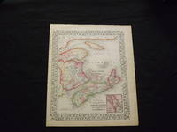
County Map of Nova Scotia, New Brunswick, Cape Breton Island, and Prince Edward Island.
by Mitchell, Samuel Augustus Jr
Unbound, colored engraved map, decorative boarder, 14"x 11". Slight toning, browning and aging; overall very bright and clear and in very good shape. Maps are wrapped with acid free board, or in rigid sleeves. The Mitchell family started to produce atlases in 1846, and continued into the early 1890s. Around 1860, S. Augustus Mitchell Jr. took over, and the atlas... Read More
Offered by Nicholas D. Riccio Rare Books & Prints
County Map of the State of New York
by Mitchell, Samuel Augustus Jr
Philadelphia, 1861. Unbound, colored engraved map, decorative boarder, 22 1/2"x 14 1/2". Slight toning and aging, just a little soiling or staining in margins; overall bright and clear and in very good shape. Maps are wrapped with acid free board, or in rigid sleeves. The Mitchell family started to produce atlases in 1846, and continued into the early... Read More
Offered by Nicholas D. Riccio Rare Books & Prints
County Map of New Jersey, Martland and Delaware.
by Mitchell, Samuel Augustus Jr
Unbound, colored engraved map, decorative boarder, 14"x 11". Slight toning and aging; a few edge nicks,bright and clear, and in otherwise very good shape. Maps are wrapped with acid free board, or in rigid sleeves. The Mitchell family started to produce atlases in 1846, and continued into the early 1890s. Around 1860, S. Augustus Mitchell Jr. took over, and the... Read More
Offered by Nicholas D. Riccio Rare Books & Prints
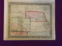
Map of Kansas, Nebraska, Colorado, and Part of Dacotah.
by Mitchell, Samuel Augustus Jr.
Unbound, colored engraved map, decorative border, 14"x 11". Slight toning and aging; a few chips and tears on top margin, overall bright and clear and in very good shape. Maps are wrapped with acid free board, or in rigid sleeves. The Mitchell family started to produce atlases in 1846, and continued into the early 1890s. Around 1860, S. Augustus Mitchell... Read More
Offered by Nicholas D. Riccio Rare Books & Prints
Map of the World in Hemispheres.
by Mitchell, Samuel Augustus Jr
Unbound, colored engraved map, decorative boarder, 14" x 11". Slight toning, darkening and aging, bottom margin narrow, upper margin with a few edge chips, and a little rough; still fairly bright and clean and in very good condition. Maps are wrapped with acid free board, or in rigid sleeves. ... Read More
Offered by Nicholas D. Riccio Rare Books & Prints
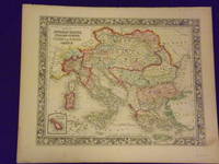
Map of the Austrian Empire, Italian States, Turkey in Europe, and Greece
by Mitchell, Samuel Augustus Jr
Philadelphia, 1861. Unbound, colored engraved map, decorative border, 14"x 11". Slight toning and aging, a little minor staining or soling in rightt margin; overall bright, clear, and crisp and in very good shape. Maps are wrapped with acid free board, or in rigid sleeves. The Mitchell family started to produce atlases in 1846, and continued into the early 1890s.... Read More
Offered by Nicholas D. Riccio Rare Books & Prints
County Map 0f the State of Maine
by Mitchell, Samuel Augustus Jr
Philadelphia, 1869. Unbound, colored engraved map, decorative boarder, 14"x 11". Slight toning and aging; bright and clear, and in otherwise very good shape. Maps are wrapped with acid free board, or in rigid sleeves. The Mitchell family started to produce atlases in 1846, and continued into the early 1890s. Around 1860, S. Augustus Mitchell Jr. took over, and the atlas... Read More
Offered by Nicholas D. Riccio Rare Books & Prints
County and Township Map of the State of Illinois
by Mitchell, Samuel Augustus Jr
Philadelphia, 1861. Unbound, colored engraved map, decorative border, 14"x 11". Slight toning and aging, a little staining in the margins; overall bright and clear and in very good shape. Maps are wrapped with acid free board, or in rigid sleeves. The Mitchell family started to produce atlases in 1846, and continued into the early 1890s. Around 1860, S. Augustus... Read More
Offered by Nicholas D. Riccio Rare Books & Prints
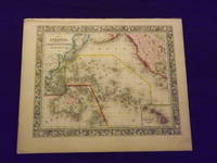
Map of Oceanica Exhibiting its Various Divisions and Island Groups.
by Mitchell, Samuel Augustus Jr
Unbound, colored engraved map, decorative border, 14" x 12". Slight toning and aging, top edge a little rough, some staining or browning in top margin; but still bright and clean. Maps are wrapped with acid free board, or in rigid sleeves. The Mitchell family started to produce atlases in 1846, and continued into the early 1890s. Around 1860, S. Augustus... Read More
Offered by Nicholas D. Riccio Rare Books & Prints
The Commerce of the North Pacific Coast. Shall We Have A Marine Asylum for Ships. Speech of Hon. John H. Mitchell of Oregon, in the Senate of the United States, January 10, 1879.
by Mitchell, John H.
Pamphlet, 8vo, stapled, 36 pp. Mitchell's name penciled on title, some creasing normal aging and browning; otherwise very good. John H. Mitchell (1835-1905) was a rather corrupt U.S. senator from Oregon who served three times between 1873 and 1905. Among his many accomplishments he managed to get himself indicted and convicted in the "Oregon Land Scandals" at the time he... Read More
Offered by Nicholas D. Riccio Rare Books & Prints
County Map of Ohio and Indiana
by Mitchell, Samuel Augustus Jr
Philadelphia, 1864. Unbound, colored engraved map, decorative border, 14"x 11 1/2". Slight toning and aging; otherwise bright and clean. Maps are wrapped with acid free board, or in rigid sleeves. The Mitchell family started to produce atlases in 1846, and continued into the early 1890s. Around 1860, S. Augustus Mitchell Jr. took over, and the atlas would be called... Read More
Offered by Nicholas D. Riccio Rare Books & Prints
Minnesota and Dacotah
by Mitchell, Samuel Augustus Jr
Philadelphia, 1861. Unbound, colored engraved map, decorative boarder, 14"x 11". Some toning and aging, a small margin stain; otherwise bright and clean. Maps are wrapped with acid free board, or in rigid sleeves. The Mitchell family started to produce atlases in 1846, and continued into the early 1890s. Around 1860, S. Augustus Mitchell Jr. took over, and the atlas... Read More
Offered by Nicholas D. Riccio Rare Books & Prints
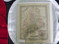
County Map of Maine.
by Mitchell, Samuel Augustus Jr.
Unbound, colored engraved map, decorative border, 14"x 11". Slight toning and aging, one or two margin nicks; overall bright and clean. Maps are wrapped with acid free board, or in rigid sleeves. The Mitchell family started to produce atlases in 1846, and continued into the early 1890s. Around 1860, S. Augustus Mitchell Jr. took over, and the atlas would be... Read More
Offered by Nicholas D. Riccio Rare Books & Prints
County Map of the State of Pennsylvania
by Mitchell, Samuel Augustus Jr
Philadelphia, 1870. Unbound, colored engraved map, decorative boarder, 14"x 11". Slight toning and aging, a few chips at the top edge; overall bright and clear and in very good shape. Maps are wrapped with acid free board, or in rigid sleeves. The Mitchell family started to produce atlases in 1846, and continued into the early 1890s. Around 1860, S.... Read More
Offered by Nicholas D. Riccio Rare Books & Prints
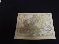
Map of Europe.
by Mitchell, Samuel Augustus Jr.
Unbound, colored engraved map, decorative border, 14"x 11". Slight browning and aging, a little foxing in margins; still overall bright and clear and in very good shape. Maps are wrapped with acid free board, or in rigid sleeves. The Mitchell family started to produce atlases in 1846, and continued into the early 1890s. Around 1860, S. Augustus Mitchell Jr. took... Read More
Offered by Nicholas D. Riccio Rare Books & Prints
Philadelphia and Camden.
by Mitchell, Samuel Augustus Jr
Unbound, colored engraved map, lined boarder, 23"x 15". Some toning, darkening and aging, a couple of small margin tears, three with archival tape repairs, slight corner crease; overall a nice impression, about very good. Maps are wrapped with acid free board, or in rigid sleeves. The Mitchell family started to produce atlases in 1846, and continued into the early 1890s.... Read More
Offered by Nicholas D. Riccio Rare Books & Prints
Map of North America
by Mitchell, Samuel Augustus Jr
Philadelphia, 1861. Unbound, colored engraved map, decorative boarder, 14"x 11". Slight toning and aging; overall very bright and clear and in very good shape. Maps are wrapped with acid free board, or in rigid sleeves. The Mitchell family started to produce atlases in 1846, and continued into the early 1890s. Around 1860, S. Augustus Mitchell Jr. took over, and... Read More
Offered by Nicholas D. Riccio Rare Books & Prints
Mitchell’s School Atlas…
by Mitchell, Samuel Augustus
Square 4to (11 ½ x 9 ½) publisher’s original quarter green calf and pictorial peach-colored boards. With 17 hand-colored copper engraved maps (5 double pages) plus insets. Spine ends and corners bumped, shelf wear, a few small dampstains, soiling; binding a bit loose, short splits to some of the centerfolds (U.S. map), and light toning and foxing to contents.... Read More
Offered by Nicholas D. Riccio Rare Books & Prints
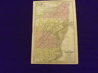
Map of the Middle States and Part of the Southern.
by Mitchell, Samuel Augustus.
Engraved colored map, 11" x17", cartouche with map information. Some slight soiling, toning and browning, archival tape repairs on reverse near split, relatively decent margins; map is generally bright and clean. Early Mitchell map of the Middle States the Mitchell's School & Family Geography. New York, Pennsylvania, and Virginia are the most visible, but a significant portion of North... Read More
Offered by Nicholas D. Riccio Rare Books & Prints
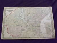
Plan of Milwaukee
by Mitchell, Samuel Augustus Jr
Philadelphia: Bradley, 1882. Unbound, colored engraved map, decorative boarder, 14"x 11 1/2". Some toning and aging, a couple of minor nicks at left edge; otherwise very good, and bright and clean. Maps are wrapped with acid free board, or in rigid sleeves. The Mitchell family started to produce atlases in 1846, and continued into the early 1890s. Around 1860,... Read More
Offered by Nicholas D. Riccio Rare Books & Prints
Map of Europe.
by Mitchell, Samuel Augustus.
Engraved colored map, 9" x12", Box like cartouche with map information. Some soiling, aging and browning, a couple of small holes in top margin where it was bound, not affecting image, otherwise very good. Interesting and detailed small map of Europe. From a school and family geography.
Offered by Nicholas D. Riccio Rare Books & Prints