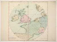
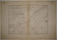
An Accurate Map of Great Britain, France & Ireland, with Part of Spain, Germany, Denmark &c. Showing at One View the True Bearing and Horizontal Distance, of any Place within 700 Miles of London; Drawn from the Best Authorities
by LAURIE & WHITTLE
London: Laurie & Whittle, 1794. unbound. Map. Engraving with hand coloring.. Image measures 20 1/8" x 20 1/8". This unusual yet beautiful hemispherical projection of Western Europe is centered on London, such that the compass bearings are drawn as straight lines. The map has a 700 mile radius that encompasses the Faroe Islands, Bergen in Norway, Munich in... Read More
Offered by Argosy Book Store
A Geohydrographic Draught of the Northern Circars or Maritime Provinces on the Coasts of Golconda and Orissa from all the Original Surveys extant of those Parts
by LAURIE & WHITTLE
London: Laurie & Whittle, 1794. unbound. Sea chart. Uncolored copper plate engraving. Image measures 21" x 30.25". Sheet measures 23.5" x 33.75". Stunning sea chart of the coasts of Golconda Coast and Odisha in East India. Extends from Ongole north to Jagannath Puri (Puri) and Konark in Odisha. Also identifies the site of the famous Black Pagoda, the... Read More
Offered by Argosy Book Store
A Chart of the South Part of Sumatra and of the Straits of Sunda and Banca with Gaspar Straits..
by LAURIE & WHITTLE
London: Laurie & Whittle, 1799. unbound. very good. Sea chart. Uncolored copper plate engraving. Image measures 24" x 32.5". Stunning chart of the southern tip of Sumatra, with the Strait of Sunda and part of Java and the Java Sea. Includes rhumb lines, depths, shoals, a compass rose and an inset map: "A Particular Chart of the... Read More
Offered by Argosy Book Store

A New Chart of the Java Sea, within the Isles of Sunda; with its Straits, and the Adjacent Seas
by LAURIE & WHITTLE
London: Laurie & Whittle, 1799. unbound. very good. Sea chart. Uncolored copper plate engraving. Image measures 23 1/8" x 34". Stunning chart of the Java Sea including part of Sumatra, Java, Bali and the southern coast Borneo. Includes rhumb lines, depths and shoals, the paths of previous explorations, a compass rose and an inset, "The East Side... Read More
Offered by Argosy Book Store
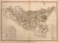
The Island and Kingdom of Sicily, According to the best Observations, & Improved..
by LAURIE & WHITTLE
London: Laurie & Whittle, 1799. unbound. Map. Engraving with original hand outline. Sheet measures 21.5" x 28.25". This incredible map of Sicily by Robert Mylne was published by Laurie and Whittle in 1799. It offers a detailed representation of the island, from Marettimo to Calabria and Alieuri to the Canal of Malta. The map highlights numerous cities, towns,... Read More
Offered by Argosy Book Store

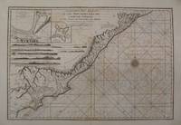
A Chart of the Coast of Pegu with the Adjacent Coast of Arakan and Tanasserim
by LAURIE & WHITTLE
London: Laurie & Whittle, 1799. unbound. very good. Sea chart. Uncolored copper plate engraving. Image measures 30 5/8" x 22". Magnificent and intricate sea chart showing the coast of the Burman Peninsula from the Bay of Bengal to the Gulf of Martaban. Details include rhumb lines, depths, and a compass rose. Dotted lines indicate rivers whose paths... Read More
Offered by Argosy Book Store
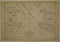
A Chart of the Western Coast of Sumatra from Touroumane to Indrapour with the Adjacent Islands
by LAURIE & WHITTLE
London: Laurie & Whittle, 1799. unbound. very good. Sea chart. Uncolored copper plate engraving. Image measures 18 7/8" x 26.25". Beautiful chart of the central western coast of Sumatra. Includes rhumb lines, depths and shoals, the paths of previous explorations, a compass rose and three inset maps: "Se-Leaga Bay", "Tappanooly Bay" and "Plan of Nattal", the last... Read More
Offered by Argosy Book Store
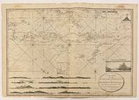
A New Chart of the Eastern Straits or The Straits to the East of Java with a Part of the Banda Sea
by LAURIE & WHITTLE
London: Laurie & Whittle, 1798. unbound. Robert Williams. Sea chart. Sheet measures 25 1/4" x 36 3/4". Wonderfully intricate sea chart of the southern East Indies, including Bali, East Timor, and parts of Java and the Banda Sea. Inset illustrations of a smoldering volcano, the Straits of Lantooca, and elevations of each island's coastlines. Robert Laurie (c. 1755... Read More
Offered by Argosy Book Store
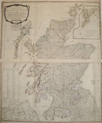
A New and Correct Map of Scotland or North Britain with all the Post and Military Roads, Divisions, &c
by LAURIE & WHITTLE
London: Sayer, 1794. unbound. Map, in two sheets. Copper plate engraving with original outline hand color. Each image measures 24.25" x 21.25". This large-scale wall map of Scotland depicts the country in intricate detail. Based on the work of Marcus Armstrong, this two-part map has a particular focus on military and post roads. Hand-colored lines divide and subdivide... Read More
Offered by Argosy Book Store
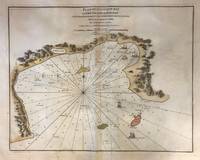
Plan of Galloon Bay on the Island of Hay-nan
by LAURIE & WHITTLE
London: Laurie & Whittle, 1794. unbound. Sea chart. Hand colored copper plate engraving. Image measures 19.5" x 25". This lovely 1794 sea chart depicts Yelong Bay or Galloon Bay on the southern coast of Hainan (Haynan), China. Rhumb lines emanate from the center of the map, spreading out in every direction toward the highly detailed coastlines of the... Read More
Offered by Argosy Book Store

A New Map of the Middle and Upper Parts of Italy, wherein are included The State of the Church, and the Grand Duchy of Tuscany; Austrian Lombardy, The States of Parma and Modena, and The REpublics of Venice, Genoa, Lucca, & ca. with the Island of Corsica
by LAURIE & WHITTLE
London: Laurie & Whittle, 1799. unbound. Map. Engraving with original hand coloring Sheet measures 26 3/4" x 19 3/4" Large map of Italy extending from the northern edge of the Kindgom of Naples to the Brenner Pass in the Alps, with the island of Corsica. Published by Laurie and Whittle in 1799. The map highlights numerous cities, towns,... Read More
Offered by Argosy Book Store
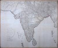
A New Map of Hindoostan from the latest authorities, Chiefly from the actual surveys made by Major James Rennell
by LAURIE & WHITTLE
London: Laurie and Whittle, 1795. unbound. Map, in two sheets, lined and joined. Copper plate engraving with original outline hand color. Overall dimensions are 48.25 x 58.5 inches. This large-scale wall map of India depicts the country in intricate detail. Mountains, rivers, forests, roads, towns are noted based on the 'Father of Indian Geography"--James Rennell's surveys. Robert Laurie... Read More
Offered by Argosy Book Store

A Chart of the West Coast of Sumatra from Old Bencoolen to Buffaloe Point containing the Road of Bencoolen and Poolo Bay
by LAURIE & WHITTLE
London: Laurie & Whittle, 1799. unbound. very good. Sea chart. Uncolored copper plate engraving. Image measures 20.5" x 24.25". Beautiful chart of the southwestern coast of Sumatra. Includes rhumb lines, depths, shoals and inland swamps, the paths of previous explorations, a compass rose and two inset maps: "Plan of Rat Island", "Plan of Poolo Bay". The coast... Read More
Offered by Argosy Book Store

A Map of the Kingdom of Ireland, Divided into Provinces Counties and Baronies, showing the Archbishopricks, Bishopricks, Cities, Boroughs, Market Towns, Villages, Barracks, Mountains, Lakes, Bogs, Rivers, Bridges Ferries, Passes, also the Great, the Branch, & the By Post Roads, together with the Inland Navigation &c
by LAURIE & WHITTLE
London: Laurie & Whittle, 1794. unbound. Map (in two panels). Engraving with original hand outline. Map in top panel measures 23.5" x 38.25, and panel measures 25.25" x 39". Map in bottom panel measures 24.75" x 38.5", and panel measures 26.5" x 39". This is an impressive 2 panel wall map of Ireland published in 1794 by Laurie... Read More
Offered by Argosy Book Store
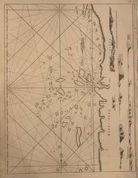
Coast of Tanasserim
by LAURIE & WHITTLE
London: Laurie & Whittle, 1761. unbound. Sea chart. Uncolored copper plate engraving. Image measures 18 1/4 x 24 1/2 inches. The Tenasserim Hills are part of a long granite mountain ridge that is older than the Himalayas. The Burmese range form a barrier between the Andaman sea and the Gulf of Thailand. Elevations shown in side profile, oriented... Read More
Offered by Argosy Book Store
Cop! A Closeup of Violence and Tragedy
by WHITTEMORE, L.H.
hardcover. 8vo, cloth, d.w. New York, (1969).
Offered by Argosy Book Store
The Super Cops; The True Story of the Cops called Batman and Robin
by WHITTEMORE, L.H.
hardcover. 8vo, cl.-backed bds. N.Y., (1973).
Offered by Argosy Book Store
The Oxford Drawing Book, or the Art of Drawing, & Theory & Practice of Perspective...New & Improved Edition
by WHITTOCK, Nathaniel
New York: Collins & Brother, 1847. hardcover. good. Mezzotint fronispiece and over 100 plates, printed four to a page. Oblong 4to, original cloth, spine rebacked, scattered foxing. New York: Collins & Brother, 1847. A New and Improved Edition. Good. Rare American edition of this enormously popular manual, with plates lithographed by Lewis & Brown, N.Y. ... Read More
Offered by Argosy Book Store
The Poet As Journalist: Life at The New Republic
by WHITTEMORE, Reed
Washington: New Republic, 1976. hardcover. 232pp., 8vo, cloth, d.w. Washington, D.C.: The New Republic Book Company, Inc., (1976).
Offered by Argosy Book Store
Pure Lives: The Earlier Biographers
by WHITTEMORE, Reed
Baltimore & London: The Johns Hopkins University Press, 1988. hardcover. near fine/very good. 159pp., 8vo, two-toned cloth, d.w. Baltimore & London: The Johns Hopkins University Press, (1988). Authors inscription and first name signature on the title page. Near fine.
Offered by Argosy Book Store
The Quest of the Golden Boy: The Life and Letters of Richard Le Gallienne
by WHITTINGTON-EGAN, Richard & SMERDON, Geoffrey
London: Unicorn Press, 1960. hardcover. very good. Frontis, illustrated. 580pp, 8vo, cloth. London: Unicorn Press, 1960. Very good.
Offered by Argosy Book Store

The DiMaggio Albums; Selections from Public and Private Collections celebrating the Baseball Career of Joe DiMaggio
by WHITTINGHAM, Richard, ed
New York: Putnam, 1989. First. hardcover. very good(-). Introduction and Commentaries by Joe DiMaggio. Many Illus. 2 Vols. 4to, blue cloth, boxed, cloth spines on both volumes and box lightly soiled, otherwise very good. New York: Putnam, (1989). Internally a fine set.
Offered by Argosy Book Store
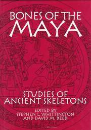
Bones of the Maya; Studies of Ancient Skeletons
by WHITTINGTON, Stephen L. and REED, David M., eds
Washington: Smithsonian, 1997. First. hardcover. fine/fine. Illus. 4to, red cloth, d.w. Washington: Smithsonian Institution Press, (1997). Fine
Offered by Argosy Book Store
Catalogue of First Editions of Stephen C. Foster (1826-1864)
by WHITTLESEY, Walter R. and Sonneck, O.G.
Washington: Government Printing Office, 1915. hardcover. very good. 79pp. Thin 4to, burgundy cloth. Washington: Government Printing Office, 1915. A very good copy.
Offered by Argosy Book Store
The Making of a National Theatre
by WHITWORTH, Geoffrey
hardcover. 308pp. 8vo, cloth, d.w.; (d.w. very worn & chipped). London, n.d.
Offered by Argosy Book Store