
Artists & Prints: Masterworks from The Museum of Modern Art
by WYE, Deborah
New York: Museum of Modern Art, 2004. hardcover. fine. Profusely illustrated in color & black & white. 288 pages, 4to, pictorial boards; minor bump to upper front corner. New York: The Museum of Modern Art, (2004). Fine. With texts by several authors.
Offered by Argosy Book Store
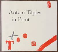
Antoni Tapies in Print
by WYE, Deborah
New York: Abrams, 1991. paperback. fine. Antoni Tapies. Illustrations in color & in black & white. 128 pages. Slim oblong 4to, stiff white pictorial wrappers. New York: Harry Abrams, (1991). First softcover edition. A fine copy
Offered by Argosy Book Store
Saucy Seaside Postcards
by WYKES, Alan
London: jupiter books, 1977. hardcover. very good(+)/very good. 131 pages, profusely illustrated in back and white and color, 4to, black buckram boards, d.w. (clear wrapper on top of that). AN overall good copy.
Offered by Argosy Book Store
Doctor Cardano: Physician Extraordinary
by WYKES, Alan
hardcover. Text illus. 187pp. Small 8vo, bds., d.w. previous owners inscription on flyleaf. London: Frederick Muller, 1969.
Offered by Argosy Book Store
A Sex By Themselves; A Collection of Cartoons about Femininity, 1846-1958
by WYKES, Alan
hardcover. very good(+)/good. Profusely illus. Thin 4to, boards, tattered d.w. London, (1958). Very good(+) in good dust wrapper.
Offered by Argosy Book Store
Wyland: The Whaling Walls
by WYLAND
Laguna Beach: Wyland Studios, 1997. hardcover. very good/very good. Wyland.. Illustrated throughout in color. 197pp. Tall and wide 4to, black boards, d.w. Laguna Beach: Wyland Studios, (1997). Slightly edge worn, still a very good copy in a very good dust wrapper. Introduction by Dr. Roger Payne and text by Mark Doyle.
Offered by Argosy Book Store

Map of America
by WYLD, James
London: James Wyld, 1857. unbound. very good(+). Map. Engraving with original hand coloring. Image measures 20 5/8" x 23 3/8". Beautiful double page map of the Western Hemisphere and the South Pacific. Details major cities, waterways and topographical features. In excellent condition with light toning and expert repair to centerfold.
Offered by Argosy Book Store
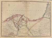
Lower Egypt and the Adjacent Deserts, with a Part of Palestine; {sand dune map}
by WYLD, James
London: James Wyld, 1840. Map. Engraving with original hand coloring Beautiful desert and railway map of Egypt centered on the Nile and the 120 mile proposed Suez canal. Provinces are listed and noted in color. Sand dunes are finely engraved with many camel routes and trails included. Arabs Bay (Plinthimetes Sinus) and 'Bedwin' routes noted in the West.... Read More
Offered by Argosy Book Store
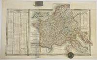
The French Empire and the Kingdom of Italy with Part of the States of the Confederation of the Rhine From Lapie's Map 1811
by WYLD, James
London: James Wyld, 1824. unbound. Map. Engraving with original hand colored outlines. Sheet measures 23" x 38" This map of the first French Empire, published by James Wyld, was made after William Faden's English edition of Lapie's 1811 map. Includes parts of Italy, Belgium, the Netherlands, and modern Germany, labeled as the Confederation of the Rhine, which only... Read More
Offered by Argosy Book Store
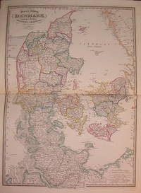
Map of the Kingdom of Denmark including the Dutchies of Holstein & Lauenburg
by WYLD, James
London: James Wyld, 1842. unbound. very good. Map. Engraving with original hand coloring. Image measures 28.25" x 20.25". Shows Denmark divided into counties, with rail lines, post and other major roads. Notes that "the Duchy of Lauenburg was annexed to the Kingdom of Denmark by treaty with the King of Prussia, signed June 4th, 1815." Lauenburg, Holstein... Read More
Offered by Argosy Book Store

Map of India, constructed with great care and research from all the latest Authorities and intended more particularly to facilitate a reference to the Civil and Military Stations
by WYLD, James
James Wyld, 1843. unbound. Map. Engraving with beautiful original hand color. Image measures 37.25" x 26 1/8". Large and unusual map of the India. Covers the subcontinent including India, Pakistan, Nepal and Sri Lanka. Includes extensive information about the provinces of of Bombay, Madras, Bengal, North Western Provinces and Bengal Provinces pertaining to military stations, collectorates, civil stations.... Read More
Offered by Argosy Book Store
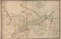
A Map of the Province of Upper Canada, describing all the New Settlements, Townships, &c. with the Countries Adjacent, From Quebec to Lake Huron.; Compiled from the Original Documents in Surveyor General's Office
by WYLD, James
London: James Wyld, 1843. unbound. Map. Hand colored engraving. 23 1/4" x 35 3/4" Incredibly detailed 1843 Railroad map of Ontario, Canada, also known as Upper Canada, divided into districts and counties. First published by David William Smyth, major roads, rivers, towns, cities, lakes, rivers, and other landmarks are noted. Shows from Michigan and Lake Huron over to... Read More
Offered by Argosy Book Store
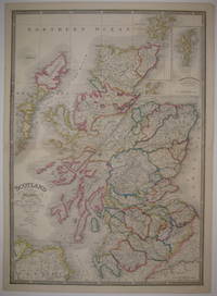
Scotland with its Islands
by WYLD, James
London: James Wyld, 1850. unbound. very good(+). Map. Engraving with original color outline. Image measures 30" x 21.25". Includes inset "The Shetland Islands with the Continuation of the Orkney Islands on a Reduced scale". In great condition, with a small chip to upper right corner.
Offered by Argosy Book Store
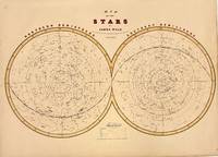
Map of the Stars
by WYLD, James
London: James Wyld, 1841. Map. Engraving with hand coloring. Sheet measures 16 1/2" x 22 3/4" . Beautiful and very scarce, this celestial chart offers a detailed view of the night sky as it was understood in 1841. The map is split into Northern and Southern Hemispheres, meeting at the First Point of Ares along the celestial equator.... Read More
Offered by Argosy Book Store
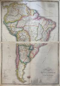
Colombia Prima or South America drawn from the Large Map in Eight Sheets
by WYLD, James
London: James Wyld, 1842. unbound. Map in 2 sheets. Engraving with original hand coloring. Each image measures 21 1/8" x 30 1/2", each page measures 22 1/2" x 33". This exquisitely detailed map was compiled from Louis Stanislas d'Arcy Delarochette's manuscript map of South America. Published shortly after independence movements swept the continent, liberating most the region from... Read More
Offered by Argosy Book Store
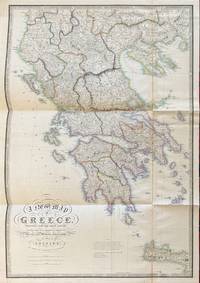
A New Map of Greece
by WYLD, James
London: James Wyld, 1840. unbound. Map. Engraving with original color outline. Image measures 28 3/8" x 19 7/8" This oversized map of Greece published in 1845 displays an impressive compilation of cartographic information from various sources listed. Wyld notes "In addition to much original information, I have availed myself of the very valuable surveys and astronomical observations of... Read More
Offered by Argosy Book Store
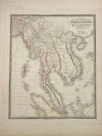
Map of the Burman Empire Including also Siam, Cochin-China, Ton-King and Malaya
by WYLD, James
London: James Wyld, 1841. unbound. Map. Engraving with original hand colored outlines. Image measures 16.5" x 13.5". This map of the Burman Empire includes the modern-day regions of Myanmar, Thailand, Vietnam, Cambodia, Laos, Malaysia, Singapore, and the tip of Borneo. The map was published in 1841, amidst a tumultuous period of increasing European colonial influence, with the British,... Read More
Offered by Argosy Book Store
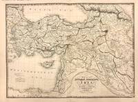
Map of the Ottoman Dominions in Asia with Adjacent Frontiers of the Russian and Persian Empires
by WYLD, James
London: James Wyld, 1843. unbound. Map. Engraving with original hand coloring. Image measures 20.25" x 27.5". Beautiful edition of Wyld's Ottoman Empire includes the Black Sea. The Sea of Maramara, the eastern of the Mediterranean including modern Cyprus, part of the Persian Gulf and part of the Caspian Sea. The map is in good condition, with some toning... Read More
Offered by Argosy Book Store
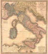
The States of Italy with their Islands, Corsica, Sardinia, Sicily, & Malta
by WYLD, James
London: James Wyld, 1844. unbound. Map. Engraving with original hand color. Image measures 24 7/8 x 21 5/8" This striking map by James Wyld covers the Italian peninsula, Sicily, Sardinia, Corsica, as well as the Ischia, the Dalmatian Coast, and the French Riviera. Notes the political divisions as laid out in the Treaty of Paris, 1815. Regional divisions... Read More
Offered by Argosy Book Store

The Book of Old Silver: English-American-Foreign
by WYLER, Seymour B.
New York: Crown Publishers, 1977. Reprint. hardcover. near fine/very good. Many black & white illustrations throughout. 401 pages. Short 4to, blue cloth, d.w. New York; Crown Publishers, (1977). Thirty-Third Printing. Top outer edges foxed, else fine in very good dust wrapper.
Offered by Argosy Book Store
Chinese Researches
by WYLIE, Alexander
Taipei: Ch'eng-Wen, 1966. hardcover. very good. Illustrated. 271pp., 8vo, green cloth; spine lightly faded. Taipei: Ch'eng-Wen Publishing Co., 1966. A very good (+) copy. Facsimile of the Shanghai, 1897 edition.
Offered by Argosy Book Store
Nets to Catch the Wind
by WYLIE, Elinor
New York: Harcourt Brace, 1921. First. hardcover. fine/fine. Small 8vo, brown cloth, d.w. New York: Harcourt Brace, 1921. First Edition. Fine. First issue on unwatermarked paper. pages 41/42 a cancel & "be" on p. 43
Offered by Argosy Book Store
Generation of Vipers
by WYLIE, Philip
hardcover. 8vo, cloth; (inner hinge weak). N.Y.: Farrar & Rinehart, (1942).
Offered by Argosy Book Store
Typed Letter Signed
by WYLIE, Philip (1902-1971)
Miami, 1945. unbound. very good. A risque T.L.S. "Philip Wylie", 4to. 1 page, Miami Beach, January 6th 1945, to journalist Thomas Jeltrop, in full: "It was indeed pleasant to hear that we found a bond in Blonds. I shall make a note of this predilection of yours, as one of my representative readers, and if I had the... Read More
Offered by Argosy Book Store
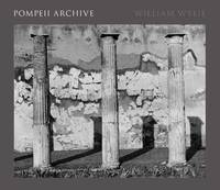
Pompeii Archive
by WYLIE, William
New Haven: Yale University Press, 2018. hardcover. fine/fine. Illustrated in black and white. 120 pages. Short oblong folio, brick red cloth, d.w. New Haven: Yale University Press, 2018. A fine copy, as new in shrinkwrap.
Offered by Argosy Book Store